

BILLINGS, Mont. (AP) — Pompeys Pillar is falling down.
The historic sandstone landmark where William Clark carved his name on July 25, 1806, is cracked and deteriorating.
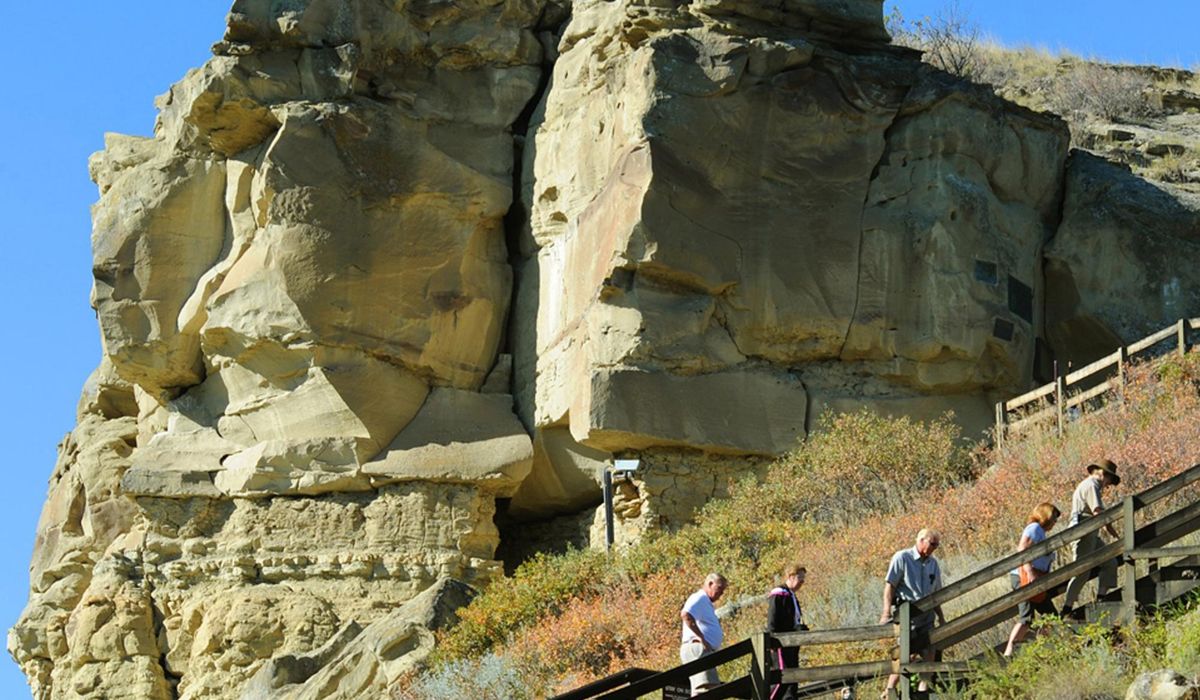
“The main gist of it is, there are these big heavy sandstone blocks supported by crumbling shale,” Dave Lefevre, Billings Field Manager for the Bureau of Land Management, tells The Billings Gazette.
Through Feb. 22, the BLM is taking comments on its proposal to keep Pompeys Pillar intact. The plan is outlined in a 77-page draft environmental assessment. The work would include filling cracks, bolting large rocks in place, creating a buttress to hold up an overhanging rock threatening to topple, spraying a silicone preservative to protect the rock and removing vegetation and loose stones. Work could start as soon as this summer.
Without the work to stabilize the feature, public access would have to end, Lefevre said.
Clark stopped at the site along the Yellowstone River, 30 miles east of Billings, after exploring a route to the Pacific Ocean with the Corps of Discovery. Also led by Meriwether Lewis, the Corps’ trip extended from May 1804 when it left St. Louis, Missouri, to 1806.
On the way back, the group split. Lewis followed the Blackfoot River upstream and then down to the Missouri. Clark and his squad explored the Yellowstone River to its confluence with the Missouri. Clark’s signature is the only visual sign of the legendary journey left on the landscape, except for archaeological discoveries at campsites.
It was Clark who named the site Pompey’s Tower. Pomp was the nickname of Sacajawea’s son. She was the Corps’ Native American guide. The editor of Clark’s journals later changed the name of the feature to Pompeys Pillar.
“As far as we’re concerned, it’s a very significant site,” said Paul Eppinger, executive director of the Friends of Pompeys Pillar. “It’s the only spot you can go to see visual evidence” of the expedition.
Long before Clark left his mark, the block of stone was known as a navigational aid and ceremonial location for Native Americans. Indigenous people also left signs of their visits in the area with paintings and etchings that have been dated to the 1700s. Earlier ones may have vanished from the highly erosive stone.
One inventory of the pillar “counted 2,000 separate names, dates and initials on 147 separate panels from the 11 sections of the butte,” according to the environmental assessment.
Recognizing the significance of the site, in 1965 the pillar was granted National Historic Landmark status. Since the 1990s it has been managed by the Bureau of Land Management. In 2006, the agency opened an interpretive center on the six-acre site that helps explain the Corps of Discovery’s trip. About 30,000 visitors annually make a pilgrimage there.
Although made of stone, Pompeys Pillar is not immune to the threats of water, cold and time.
“The geologic makeup of the Pillar (sandstone, shale, and siltstone) lends itself to degradation through wind, moisture, and temperature changes,” the EA noted. “Investigation into the stability of the Pillar led to its temporary closure in March of 2020 due to concerns for public safety.”
The BLM hired a geotechnical engineering firm to examine the site before reopening the stairways that wrap around and climb up the feature. However, the agency kept the lower viewing deck closed out of precaution against falling rock.
In July 2020, the engineering firm also installed a Rock Block Monitoring System to detect and automatically report any movement at different locations “to more thoroughly monitor geohazards.” Two areas of specific concern are the Signature Block and Turtle Rock areas.
Installation of the monitoring system gave the BLM enough confidence to reopen the sandstone block to visitors.
“It’s been a pretty complex project and has been heavily evaluated,” said John Reffit, monument manager for the BLM.
The whole point, he added, is to preserve the historic integrity of the signatures, pictographs and petroglyphs on the mound while ensuring visitors are safe.
Lefevre couldn’t say what the cost of the work might be until it goes out for bid, but indicated it would be one of the more significant contracts the agency has issued for maintenance. Part of the funding would come from the Great American Outdoors Act, he said.
“The idea is that it’s a lifetime fix, not a temporary solution,” Lefevre said.
A somewhat similar project is being considered to preserve portions of Mesa Verde National Park in Colorado where a slab of sandstone is threatening to fall off above one of the park’s historic cliff dwellings used by Pueblo Indians.
Pictograph Caves outside Billings has been repaired to preserve the rock at the historic site containing ancient Native American rock art.
Kevin Kooistra, executive director of the Western Heritage Center museum in Billings, noted that Clark’s signature at Pompeys has been recarved twice because it was eroding.
“In the museum, our job is only to slow down the inevitable decomposition of artifacts like photographs,” he said.
Even with climate controlled storage and special handling they often fade with time, although their life can be significantly extended, he added.
“You record and document it well, but let it go,” Kooistra said.


